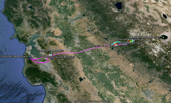
 For those of you interested in seeing the Hetch Hetchy Aqueduct up close on Google Earth. Download the Hetch Hetchy KML in the library on the right and open it in Google Earth. This a pared down version of my more complete KML but it still has a lot of stuff to explore. The library now includes the LA Aqueduct, Colorado River Aqueduct, State Water Project and Hetch Hetchy Aqueduct.
Hetch Hetchy Aqueduct on Google Earth
Posted In Kml's
The Bay Crossing alignment is out of date. The visible pipeline/bridge at Dumbarton has been abandoned, replaced by a deep tunnel beneath the bay.
https://www.sfgate.com/news/article/Big-debut-for-1st-of-its-kind-water-tunnel-below-5822934.php#photo-6999442
Thank you Greg for bringing that to my attention. You can expect an update on Droughtmath soon.
I ‘ve tried several times to download the kmz file for Hetch Hetchy with no success. Am I missing something or is there somewhere else I can download it? thanks.
David,
Thank you for bring this to my attention. I just transferred the site to a newer server. I’ll look into it and correct the issue.
Thanks, it downloaded easily. This appears to be the HH aqueduct. I’m actually looking for a detailed map for the HH regional water system, a high-pressure, 42″ pipe that runs through residential neighborhoods in Hillsborough and San Mateo. I was provided with a close-up map of a property I’m appraising and am looking to identify other properties impacted by the line. The owner asked the PUC for a detailed area map, but they’ve dragged their feet for months. Any thoughts?